Hateruma, Japan
Landing Point · JP Japan
1
Connected Cables
JP
Country
24.06°
Latitude
123.78°
Longitude
Ctrl + Scroll to zoom
Connected Cables
| Cable | Status |
|---|---|
| Okinawa Remote Islands | Active |
Live Performance
50
measurements
13
probes
195
days monitored
223.1
ms avg RTT
0
anomalies
RTT measurements to this landing point from 2026-03-23 through 2026-10-04 - live ICMP round-trip time via our monitoring probes. Recomputed daily. ✓ No anomalies detected in the monitored period.
Measurement sources
| Probe | Location | Samples | Avg |
|---|---|---|---|
| own probe | Almaty KZ | 9 | 288.4 ms |
| #6410 own probe | Sao Paulo BR | 6 | 281.2 ms |
| #6427 own probe | Sydney AU | 5 | 185.1 ms |
| #6487 | control probe | 5 | 83.6 ms |
| #7062 own probe | Cape Town ZA | 5 | 397.6 ms |
| #7533 | control probe | 3 | 44.7 ms |
| #60763 | control probe | 3 | 41.0 ms |
| own probe | Minsk BY | 3 | 302.2 ms |
| own probe | Tbilisi GE | 3 | 297.3 ms |
| own probe | Jerusalem IL | 3 | 290.0 ms |
| #1002754 | control probe | 2 | 31.3 ms |
| own probe | Moscow RU | 2 | 256.3 ms |
| #65655 | control probe | 1 | 41.5 ms |
About Hateruma, Japan
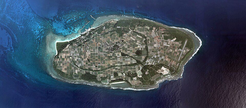
Hateruma: Connectivity at Japan's Southernmost Edge
Hateruma, a small island in the Yaeyama District of Okinawa Prefecture, holds a unique distinction as Japan's southernmost inhabited island. While its geographic isolation might suggest limited connectivity, the island plays a key role in the Okinawa Remote Islands submarine cable network. This single cable, which became operational in 2017, links Hateruma to eight other landing points across the Okinawa region, ensuring reliable communication and data flow within Japan.The Okinawa Remote Islands Cable
The Okinawa Remote Islands cable spans 915 kilometers and exclusively serves domestic locations within Japan. Its chain includes landing points at Aguni, Ama, Itoman, Kumejima, Tarama, Tokashiki, Yomitan, and Yonaguni, stitching together a network that supports the connectivity needs of remote islands across the Okinawa Prefecture. For Hateruma, this cable is its sole link to the broader digital infrastructure of Japan, connecting the island to regional hubs and, ultimately, the national network. Unlike major landing points such as Shima (12 cables) or Maruyama (9 cables), Hateruma operates with just one cable. This places it in the lower tier of Japan's 68 submarine cable landing points in terms of cable count. However, in the context of its remote location and modest population, the presence of even one cable is significant, enabling essential communication and internet services.Latency Insights: A Window into Performance
GeoCables' monitoring of the Hateruma landing point provides valuable insights into its performance. Across 29 completed latency checks from nine source cities, the average round-trip latency was measured at 264 milliseconds, with the best observed latency reaching a swift 80 milliseconds. These figures highlight the efficiency of the Okinawa Remote Islands cable in maintaining connectivity despite Hateruma's remote position.Hateruma's Role in Regional Connectivity
While Hateruma may not rival the cable density of larger hubs like Naha (4 cables) or Minamiboso (4 cables), its inclusion in the Okinawa Remote Islands cable chain ensures that even Japan's southernmost inhabited island remains connected. This connection is essential for the island's residents, who rely on digital infrastructure for communication, education, and access to services. Hateruma's geographic isolation is counterbalanced by its integration into a well-planned regional network. The Okinawa Remote Islands cable not only supports Hateruma but also strengthens connectivity across the Yaeyama Islands, fostering a sense of unity among these scattered communities.A Gateway to the World
For Hateruma, the Okinawa Remote Islands cable serves as both a lifeline and a gateway, linking the island to the broader Japanese network and, indirectly, to the global digital ecosystem. Its single cable may seem modest compared to Japan's larger landing points, but it is a testament to the country's commitment to connecting even its most remote corners.What next: Hateruma, Japan in the global directory of cable landing points; see surrounding routes on the interactive submarine cable map or follow live network monitoring.
Other Landing Points in Japan
JP Aguni, Japan
26.5872°N 127.2290°E
JP Ajigaura, Japan
36.3836°N 140.6123°E
JP Akita, Japan
39.7167°N 140.1167°E
JP Ama, Japan
26.2310°N 127.2923°E
JP Aogashima, Japan
32.4572°N 139.7656°E
JP Awashimaura, Japan
38.4646°N 139.2528°E
JP Chichijima, Japan
27.0665°N 142.2041°E
JP Chikura, Japan
34.9767°N 139.9547°E
JP Emi, Japan
35.0624°N 140.0611°E
JP Fukuoka, Japan
33.5904°N 130.4017°E
JP Gusukube, Japan
24.7515°N 125.3873°E
JP Hachijo, Japan
33.1123°N 139.7968°E
Landing Point
- CountryJP Japan
- Coordinates24.0600°N 123.7784°E
- Connected Cables1
See Real Cable Routes
View actual submarine cable routing from Hateruma, Japan - with backbone nodes, distance calculations, and latency estimates
Open Calculator →
Submarine cables
Land fiber
Live probes