Arutua, French Polynesia
Landing Point · PF French Polynesia
1
Connected Cables
PF
Country
15.29°
Latitude
146.79°
Longitude
Ctrl + Scroll to zoom
Connected Cables
| Cable | Status |
|---|---|
| Natitua | Active |
📡 Live Performance
44
measurements
13
probes
134
days monitored
278.0
ms avg RTT
0
anomalies
RTT measurements to this landing point from 2026-03-02 through 2026-07-15 - live ICMP round-trip time via our monitoring probes. Recomputed daily. ✓ No anomalies detected in the monitored period.
Measurement sources
| Probe | Location | Samples | Avg |
|---|---|---|---|
| #1014969 own probe | Jerusalem IL | 8 | 295.2 ms |
| #1014597 own probe | Tbilisi GE | 7 | 331.8 ms |
| #1014473 own probe | Minsk BY | 6 | 307.5 ms |
| #1014589 own probe | Almaty KZ | 6 | 323.0 ms |
| #6410 own probe | Sao Paulo BR | 3 | 266.3 ms |
| #6427 own probe | Sydney AU | 3 | 238.5 ms |
| #6487 own probe | Singapore SG | 3 | 281.3 ms |
| #1015523 own probe | Moscow RU | 2 | 272.7 ms |
| #1015984 own probe | Balancer IL | 2 | 293.9 ms |
| #53098 | control probe | 1 | 3.7 ms |
| #54473 | control probe | 1 | 4.4 ms |
| #1001562 | control probe | 1 | 3.1 ms |
| #1015563 own probe | Saint Petersburg RU | 1 | 263.3 ms |
About Arutua, French Polynesia
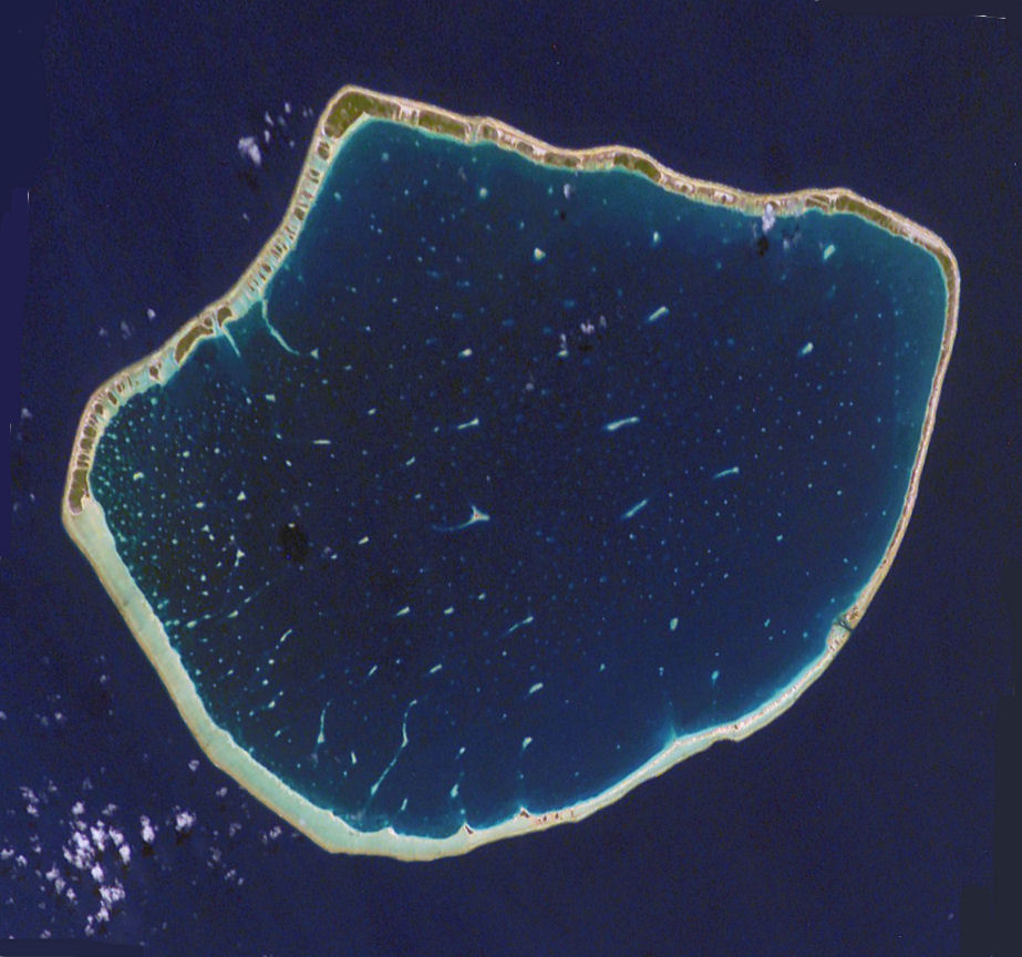
Arutua: A Singular Gateway in the Tuamotu Archipelago
Arutua, a serene atoll in the Tuamotu group of French Polynesia, may seem remote, but it plays a quiet yet important role in the region's connectivity. Located 40 km southwest of the larger Rangiroa Atoll and just 16 km east of Apataki, Arutua is a landing point for the Natitua submarine cable, which connects it to a broader network of islands within French Polynesia. This cable, operational since 2018, is the sole submarine cable serving Arutua, linking it to 10 other landing points across the archipelago.The Natitua Cable: Stitching Together the Tuamotus
The Natitua cable spans 2,680 km and is a domestic marvel, connecting islands that are otherwise separated by vast stretches of ocean. Its chain includes prominent peers such as Rangiroa, Fakarava, and Hao, as well as smaller atolls like Takaroa and Manihi. While Arutua hosts just one cable, it is part of a critical web that ensures reliable connectivity for the Tuamotu group. This domestic network does not extend beyond French Polynesia but provides essential links between islands, enabling local communication and internet access. Arutua's position is notable when compared to other landing points in French Polynesia. Larger hubs like Papenoo and Faratea host multiple cables, serving as international gateways or regional hubs. In contrast, Arutua's single cable reflects its role as a local connector rather than a major transit point. Despite this, the Natitua cable ensures that even smaller atolls like Arutua remain integrated into the region's digital ecosystem.Latency Insights: Measuring Connectivity Performance
GeoCables' unique monitoring data offers valuable insights into the performance of the Natitua cable at Arutua. Across 44 completed latency checks from 13 source cities, the average round-trip latency was measured at 278 ms. Impressively, the best observed latency was just 3 ms, highlighting the cable's ability to deliver swift and reliable connections under optimal conditions. These figures underscore the importance of submarine cables in overcoming the geographical isolation of the Tuamotu islands.Life on Arutua: A Remote Yet Connected Community
Arutua itself is a picturesque atoll, known for its tranquil lagoon and traditional Polynesian lifestyle. While its population is modest, the connectivity provided by the Natitua cable has undoubtedly enhanced opportunities for communication, education, and commerce. Residents can now access digital services that were once out of reach, bridging the gap between their remote location and the wider world.A Small Node in a Vast Network
Arutua's role in French Polynesia's submarine cable network may be modest, but it is meaningful. As part of the Natitua chain, it contributes to the cohesion of the Tuamotu Archipelago, ensuring that even the most isolated atolls remain connected. In a region defined by its scattered geography, every landing point matters - and Arutua is no exception.What next: Arutua, French Polynesia in the global directory of cable landing points; see surrounding routes on the interactive submarine cable map or follow live network monitoring.
Other Landing Points in French Polynesia
PF Fakarava, French Polynesia
16.3103°S 145.6246°W
PF Faratea, French Polynesia
17.7186°S 149.3059°W
PF Hao, French Polynesia
18.2158°S 140.9081°W
PF Hitia'a, French Polynesia
17.7233°S 149.3081°W
PF Hiva Oa, French Polynesia
9.7547°S 139.0211°W
PF Huahine, French Polynesia
16.7301°S 151.0001°W
PF Kaukura, French Polynesia
15.7414°S 146.6738°W
PF Makemo, French Polynesia
16.5396°S 143.8672°W
PF Manihi, French Polynesia
14.4029°S 145.9581°W
PF Mitirapa, French Polynesia
17.7341°S 149.3252°W
PF Moorea, French Polynesia
17.5388°S 149.8296°W
PF Nuku Hiva, French Polynesia
8.8605°S 140.1421°W
Landing Point
- CountryPF French Polynesia
- Coordinates15.2899°S 146.7862°W
- Connected Cables1
See Real Cable Routes
View actual submarine cable routing from Arutua, French Polynesia - with backbone nodes, distance calculations, and latency estimates
Open Calculator →
🌊 Submarine cables
🛤 Land fiber
📡 Live probes