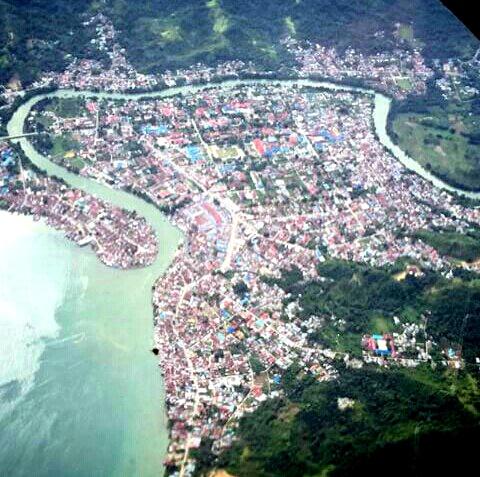
Tanjung Selor, Indonesia
Landing Point · ID Indonesia
Connected Cables
| Cable | Status |
|---|---|
| Tarakan Selor Cable System (TSCS) | Active |
📡 Live Performance
RTT measurements to this landing point from 2026-04-28 through 2026-05-03 - live ICMP round-trip time via our monitoring probes. Recomputed daily. ✓ No anomalies detected in the monitored period.
Measurement sources
| Probe | Location | Samples | Avg |
|---|---|---|---|
| #1014473 own probe | Minsk BY | 2 | 226.5 ms |
| #1014589 own probe | Almaty KZ | 2 | 261.0 ms |
| #1014597 own probe | Tbilisi GE | 2 | 211.5 ms |
| #1014969 own probe | Jerusalem IL | 2 | 224.9 ms |
| #1015313 own probe | Sevastopol UA | 2 | 230.0 ms |
| #1015523 own probe | Moscow RU | 2 | 207.7 ms |
About Tanjung Selor, Indonesia
Tanjung Selor: Submarine Cable Landing Point
Tanjung Selor is a town on the northeastern coast of Borneo, serving as the capital of North Kalimantan province and of Bulungan Regency in Indonesia. As a settlement positioned along the Kayan River estuary near the Celebes Sea, it forms part of Indonesia's broader submarine cable geography, which spans 70 cables across 139 landing points nationwide. One submarine cable lands at Tanjung Selor, connecting it to the domestic Indonesian cable network.
The single cable serving Tanjung Selor is the Tarakan Selor Cable System (TSCS), a short intra-national link that ties this provincial capital to another point within Indonesia. Given the short length of this system and its entirely domestic routing, Tanjung Selor functions as a regional connectivity node within Indonesian Borneo rather than as an intercontinental or international gateway.
Cables Landing at Tanjung Selor
The Tarakan Selor Cable System (TSCS) is an 83-kilometre submarine cable that reached ready-for-service status in 2014, with a draft designation. Both endpoints of this cable fall within Indonesia, making it a purely domestic connection. The cable's name indicates a link between Tarakan — a city and island off the northeastern coast of Borneo — and Tanjung Selor, providing a direct undersea path between two significant population centres in North Kalimantan. At 83 kilometres, TSCS is a short-haul system designed to serve inter-locality connectivity within the province rather than long-distance traffic aggregation.
Regional Context
Within Indonesia's submarine cable landscape, Tanjung Selor hosts one cable, placing it in the top 62 percent of the country's 143 landing points by cable count. Major Indonesian landing points such as Batam, Jakarta, and Tanjung Pakis each host nine or more cables, while Tanjung Selor's single domestic cable reflects its role as a provincial endpoint rather than a national hub. Its position is nonetheless consistent with Indonesia's broader infrastructure pattern, in which numerous landing points across the archipelago serve localised intra-island or inter-island connectivity needs.
Network Role
Tanjung Selor functions as a single-cable terminus within the Indonesian domestic submarine cable network. The TSCS links it directly to Tarakan, enabling undersea data transmission between two of North Kalimantan's key urban centres without relying solely on terrestrial or overland routes through Borneo's interior. This is particularly relevant given the geographic character of the region, where river and sea corridors have historically been the primary means of movement and communication.
As a terminus rather than a transit or aggregation point, Tanjung Selor does not currently serve as a hub through which traffic from other cable systems passes. Within Indonesia's submarine cable graph — one of the world's most distributed, given the archipelago's geography — landing points like Tanjung Selor represent the outermost nodes that extend connectivity to provincial capitals and smaller cities beyond the major international gateways.
What next: Tanjung Selor, Indonesia in the global directory of cable landing points; see surrounding routes on the interactive submarine cable map or follow live network monitoring.
Other Landing Points in Indonesia
Landing Point
- CountryID Indonesia
- Coordinates2.5720°N 117.8194°E
- Connected Cables1
See Real Cable Routes
View actual submarine cable routing from Tanjung Selor, Indonesia - with backbone nodes, distance calculations, and latency estimates
Open Calculator →