Sangata, Indonesia
Landing Point · ID Indonesia
Connected Cables
| Cable | Status |
|---|---|
| JaKa2LaDeMa | Active |
Live Performance
RTT measurements to this landing point from 2026-05-21 through 2026-10-15 - live ICMP round-trip time via our monitoring probes. Recomputed daily. ✓ No anomalies detected in the monitored period.
Measurement sources
| Probe | Location | Samples | Avg |
|---|---|---|---|
| #6410 own probe | Sao Paulo BR | 13 | 366.7 ms |
| #6427 own probe | Sydney AU | 13 | 177.3 ms |
| own probe | Almaty KZ | 13 | 258.1 ms |
| #7062 own probe | Cape Town ZA | 12 | 314.6 ms |
| #50462 | control probe | 8 | 28.4 ms |
| #65901 | control probe | 8 | 113.3 ms |
| #6487 | control probe | 7 | 18.8 ms |
| #7108 | control probe | 5 | 43.5 ms |
| #6568 own probe | Singapore SG | 2 | 52.7 ms |
| own probe | Minsk BY | 2 | 269.5 ms |
| own probe | Tbilisi GE | 2 | 306.3 ms |
| own probe | Jerusalem IL | 1 | 228.3 ms |
| own probe | Moscow RU | 1 | 205.9 ms |
About Sangata, Indonesia
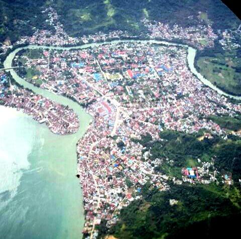
How the Internet Reaches Sangata, Indonesia
Sangata is a coastal town in East Kalimantan province, on the eastern seaboard of the island of Borneo, Indonesia. As an Indonesian coastal location, it has direct access to submarine cable infrastructure, with international and inter-island internet traffic arriving via a single submarine cable that terminates at the town. Sangata is a single-cable terminus rather than a node along a multi-cable corridor, meaning all of its submarine-delivered connectivity flows through one route.
Indonesia's broader submarine cable network spans 40 cables landing across 97 points nationwide. Within that network, Sangata represents a smaller, dedicated terminus serving the East Kalimantan region through its one landed cable, the JaKa2LaDeMa.
The Cable Serving Sangata
The JaKa2LaDeMa cable - 1,700 km in length, ready for service in 2010 - connects Sangata to five other Indonesian landing points: Banjarmasin and Beculuk (both in Kalimantan), and Denpasar, Gianyar, and Ketapang further across the Indonesian archipelago. The cable's name reflects its route linking Java, Kalimantan, and other major islands. This is entirely a domestic Indonesian cable system, meaning it carries inter-island traffic between Indonesian locations rather than connecting Indonesia to foreign countries directly. International traffic reaching Sangata travels first through this cable to other Indonesian hubs, from which onward international cables handle the wider global routing.
Regional Context
Indonesia hosts 40 submarine cables landing across 97 points, with the country's first cable entering service in 2003 and an average cable length of 2,591 km across the network. Sangata is one of the smaller terminuses in this national picture, served by a single domestic cable. Major regional peers include Batam (15 cables), Jakarta (7 cables), and Tanjung Pakis (7 cables), which serve as the primary international gateways for the country. Sangata's single-cable connection reflects its position as a regional endpoint rather than a national hub.
What This Means for Connectivity
Because Sangata is served exclusively by the JaKa2LaDeMa cable, all submarine-delivered internet traffic to and from the town flows through this one route. An outage on this cable would directly affect every service dependent on it for inter-island connectivity. The cable reaches Banjarmasin, Beculuk, Denpasar, Gianyar, and Ketapang - all Indonesian locations - meaning the traffic it carries is fundamentally inter-island and domestic in nature, stitching Sangata into the broader Indonesian internet rather than connecting it directly to international networks.
Understanding Sangata's position - a single-cable domestic terminus on eastern Borneo - illustrates how Indonesia's vast archipelago relies on layered submarine cable infrastructure, with smaller regional endpoints feeding into larger multi-cable hubs that in turn handle international routing.
What next: Sangata, Indonesia in the global directory of cable landing points; see surrounding routes on the interactive submarine cable map or follow live network monitoring.
Other Landing Points in Indonesia
Landing Point
- CountryID Indonesia
- Coordinates0.3269°N 117.5510°E
- Connected Cables1
See Real Cable Routes
View actual submarine cable routing from Sangata, Indonesia - with backbone nodes, distance calculations, and latency estimates
Open Calculator →