Cumaná, Venezuela
Landing Point · VE Venezuela
1
Connected Cables
VE
Country
10.45°
Latitude
64.18°
Longitude
Ctrl + Scroll to zoom
Connected Cables
| Cable | Status |
|---|---|
| Venezuelan Festoon | Active |
Live Performance
70
measurements
15
probes
204
days monitored
147.9
ms avg RTT
0
anomalies
RTT measurements to this landing point from 2026-03-15 through 2026-10-06 - live ICMP round-trip time via our monitoring probes. Recomputed daily. ✓ No anomalies detected in the monitored period.
Measurement sources
| Probe | Location | Samples | Avg |
|---|---|---|---|
| own probe | Minsk BY | 12 | 149.8 ms |
| #6410 own probe | Sao Paulo BR | 9 | 122.9 ms |
| #6427 own probe | Sydney AU | 8 | 267.9 ms |
| #6487 | control probe | 5 | 246.2 ms |
| #7049 | control probe | 5 | 37.9 ms |
| #7630 | control probe | 5 | 8.4 ms |
| own probe | Saint Petersburg RU | 5 | 152.4 ms |
| own probe | Almaty KZ | 4 | 198.1 ms |
| #1005868 | control probe | 3 | 47.5 ms |
| own probe | Tbilisi GE | 3 | 177.2 ms |
| own probe | Moscow RU | 3 | 149.8 ms |
| own probe | Kyiv UA | 3 | 145.5 ms |
| own probe | Jerusalem IL | 2 | 161.9 ms |
| #1017223 | control probe | 2 | 61.3 ms |
| #6568 own probe | Singapore SG | 1 | 285.2 ms |
About Cumaná, Venezuela
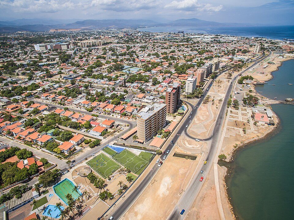
Cumaná: A Historic City with Modern Connectivity
Cumaná, the capital of Venezuela's Sucre State, holds a unique place in history as the oldest continuously-inhabited Hispanic-established city in South America. Founded by Spain on the mainland Americas, this city has a rich past marked by resilience, including indigenous resistance that led to its refounding multiple times. Today, Cumaná blends its historical significance with modern infrastructure, serving as a landing point for the Venezuelan Festoon submarine cable.The Venezuelan Festoon: Stitching Coastal Venezuela Together
The Venezuelan Festoon cable, operational since 1998, is a domestic network connecting 12 landing points along Venezuela's coastline. With a total length of 1200 km, this cable forms a chain linking cities like Cabimas, Camuri, Carúpano, and Puerto La Cruz, among others. Cumaná's inclusion in this network underscores its importance in regional connectivity, even as it hosts only one cable. Unlike larger hubs such as Punto Fijo, which accommodates two cables, Cumaná's role is more focused within the domestic framework. The Venezuelan Festoon does not extend internationally, emphasizing its purpose in strengthening local and regional communication. This network enables data flow between coastal cities, supporting industries, services, and communities along Venezuela's shores.Latency Insights: A Reliable Connection
GeoCables' monitoring reveals that Cumaná's connectivity through the Venezuelan Festoon offers consistent performance. With 27 completed latency checks from 10 source cities, the average round-trip latency is measured at 178 ms, with the best observed latency at 140 ms. These figures indicate stable and reliable connectivity, suitable for local and regional data exchange.Positioning Cumaná in Venezuela's Cable Landscape
Venezuela hosts five submarine cables across 15 landing points, with an average cable length of 4279 km. Cumaná, with its single cable, ranks in the top 93% of landing points by cable count, reflecting its modest but meaningful role in the country's digital infrastructure. While larger hubs like Punto Fijo may offer more extensive connectivity options, Cumaná's inclusion in the Venezuelan Festoon ensures it remains a key link in the domestic chain.Connectivity Supporting a Historic City
Cumaná's historical legacy as a city of firsts in the Americas is complemented by its modern role in Venezuela's digital landscape. The Venezuelan Festoon cable provides the city with reliable domestic connectivity, linking it to other coastal cities and supporting local industries and services. Though it may not serve as a major international hub, Cumaná's connection to this cable ensures its place in the broader network that stitches Venezuela's coastline together.What next: Cumaná, Venezuela in the global directory of cable landing points; see surrounding routes on the interactive submarine cable map or follow live network monitoring.
Other Landing Points in Venezuela
VE Cabimas, Venezuela
10.3960°N 71.4511°W
VE Camuri, Venezuela
10.6065°N 66.8782°W
VE Carúpano, Venezuela
10.6668°N 63.2505°W
VE Chichiriviche, Venezuela
10.9286°N 68.2845°W
VE Coro, Venezuela
11.4028°N 69.6778°W
VE Higuerote, Venezuela
10.4803°N 66.0981°W
VE La Guaira, Venezuela
10.6032°N 66.8896°W
VE Maiquetia, Venezuela
10.5994°N 66.9603°W
VE Maracaibo, Venezuela
10.6882°N 71.5984°W
VE Porlamar, Venezuela
10.9553°N 63.8476°W
VE Puerto Cabello, Venezuela
10.4781°N 68.0096°W
VE Puerto La Cruz, Venezuela
10.2025°N 64.6449°W
Landing Point
- CountryVE Venezuela
- Coordinates10.4543°N 64.1821°W
- Connected Cables1
See Real Cable Routes
View actual submarine cable routing from Cumaná, Venezuela - with backbone nodes, distance calculations, and latency estimates
Open Calculator →
Submarine cables
Land fiber
Live probes