Bushehr, Iran
Landing Point · IR Iran
Connected Cables
Live Performance
RTT measurements to this landing point from 2026-03-16 through 2026-10-04 - live ICMP round-trip time via our monitoring probes. Recomputed daily. ✓ No anomalies detected in the monitored period.
Measurement sources
| Probe | Location | Samples | Avg |
|---|---|---|---|
| own probe | Tbilisi GE | 13 | 122.5 ms |
| own probe | Jerusalem IL | 11 | 136.2 ms |
| #6410 own probe | Sao Paulo BR | 10 | 238.0 ms |
| #6427 own probe | Sydney AU | 10 | 334.0 ms |
| own probe | Balancer IL | 9 | 134.9 ms |
| own probe | Minsk BY | 3 | 59.2 ms |
| own probe | Almaty KZ | 3 | 122.6 ms |
| own probe | Sevastopol UA | 1 | 100.1 ms |
| own probe | Moscow RU | 1 | 116.1 ms |
| own probe | Odessa UA | 1 | 73.2 ms |
About Bushehr, Iran
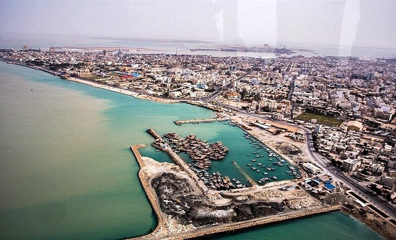
Bushehr, Iran: Submarine Cable Landing Point
Bushehr is a port city on the Persian Gulf coast of Iran, serving as the capital of Bushehr Province. Its position along the Gulf gives it direct access to the submarine cable corridor that connects Iran with its Gulf neighbors and extends outward toward South Asia. Two landings of the Gulf Bridge International Cable System/Middle East North Africa Cable System (GBICS/MENA) terminate at Bushehr, making it one of Iran's more active submarine cable landing points.
The GBICS/MENA system links Bushehr to a group of Gulf states - Bahrain, Iraq, Kuwait, and Oman - as well as to India, establishing both a regional intra-Gulf connectivity path and an intercontinental link toward South Asia. The presence of two recorded landings of this system at Bushehr reflects the cable's layered deployment across the region.
Cables Landing at Bushehr
The Gulf Bridge International Cable System/Middle East North Africa Cable System (GBICS/MENA) is a 5,270-kilometer submarine cable system that reached ready-for-service status in 2012. It connects Bushehr with landing points in Bahrain, India, Iraq, Kuwait, and Oman, forming a loop through the Persian Gulf and extending into the Arabian Sea toward the Indian subcontinent. A second recorded entry for this cable - in draft status - lists the same regional connectivity across Bahrain, India, Iraq, Kuwait, and Oman, with the addition of Qatar as a connected country. Together, these two entries represent the published and draft stages of the GBICS/MENA system's deployment profile at Bushehr.
Regional Context
Among Iran's seven submarine cable landing points, Bushehr ranks in the upper tier by cable count, hosting two cables alongside Soroosh Platform, which also hosts two. The leading landing points in Iran by cable count are Chabahar and Jask, each with three cables, while Bandar Abbas, Ganaveh, and Khark Island each host a single cable. Bushehr thus sits in the mid-to-upper range of Iran's cable infrastructure landscape.
Network Role
Bushehr functions as a dual-entry terminus for the GBICS/MENA system, providing Iran with connectivity into both the Persian Gulf sub-region and the broader Indian Ocean corridor. The cable's reach to India means that Bushehr is not limited to intra-Gulf connectivity but also participates in a longer-haul route bridging the Middle East and South Asia. The addition of Qatar in the draft record extends the range of directly connected Gulf states from this landing point.
In the regional submarine cable graph, Bushehr's role as a multi-entry landing point for a single intercontinental system distinguishes it from single-cable termini elsewhere in Iran, reinforcing its position as a meaningful node in the Gulf's undersea network architecture.
What next: Bushehr, Iran in the global directory of cable landing points; see surrounding routes on the interactive submarine cable map or follow live network monitoring.
Other Landing Points in Iran
Landing Point
- CountryIR Iran
- Coordinates28.9700°N 50.8427°E
- Connected Cables2
See Real Cable Routes
View actual submarine cable routing from Bushehr, Iran - with backbone nodes, distance calculations, and latency estimates
Open Calculator →