Port Said, Egypt
Landing Point · EG Egypt
Connected Cables
| Cable | Status |
|---|---|
| 2Africa | Active |
| FLAG Europe-Asia (FEA) | Active |
| Medusa Submarine Cable System | Active |
| Red2Med | Active |
| SeaMeWe-6 | Active |
Live Performance
RTT measurements to this landing point from 2026-03-28 through 2026-10-09 - live ICMP round-trip time via our monitoring probes. Recomputed daily. ✓ No anomalies detected in the monitored period.
Measurement sources
| Probe | Location | Samples | Avg |
|---|---|---|---|
| own probe | Tbilisi GE | 9 | 96.5 ms |
| own probe | Jerusalem IL | 9 | 108.6 ms |
| #6410 own probe | Sao Paulo BR | 7 | 364.0 ms |
| #6427 own probe | Sydney AU | 7 | 307.7 ms |
| own probe | Minsk BY | 5 | 82.5 ms |
| own probe | Balancer IL | 5 | 99.1 ms |
| own probe | Almaty KZ | 4 | 144.1 ms |
| own probe | Moscow RU | 4 | 96.9 ms |
| own probe | Sevastopol UA | 3 | 133.8 ms |
| #724 | control probe | 2 | 238.8 ms |
| own probe | Odessa UA | 2 | 86.1 ms |
| own probe | Saint Petersburg RU | 1 | 96.8 ms |
| own probe | DVM IL | 1 | 97.7 ms |
About Port Said, Egypt
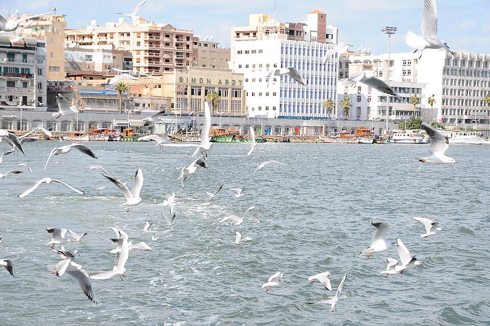
Port Said, Egypt is a submarine cable landing point in Egypt (coordinates 31.2593°, 32.2845°). It serves 5 submarine cable systems, making it a significant node in Egypt's international connectivity infrastructure.
Port Said is a port city that lies in northeast Egypt extending about 30 km (19 mi) along the coast of the Mediterranean Sea, straddling the west bank of the northern mouth of the Suez Canal. The city is the capital of the Port Said Governorate and it forms the majority of the governorate, where its seven districts comprise seven of the governorate's eight regions. In 2024 it had a population of 790,000 people. Wikipedia
Connected submarine cables
| Cable | RFS | Length | Owners |
|---|---|---|---|
| Medusa Submarine Cable System | 2026 | 8,760 km | AFRIX Telecom |
| SeaMeWe-6 | 2026 | 21,700 km | Bahrain Telecommunications Company (Batelco), Bangladesh Submarine Cable Company Limited (BSCCL), Bharti Airtel, … |
| 2Africa | 2024 | 45,000 km | Bayobab, China Mobile, Meta, … |
| Red2Med | 2023 | 420 km | Telecom Egypt |
| FLAG Europe-Asia (FEA) | 1997 | 28,000 km | FLAG |
Operators landing at Port Said, Egypt
Cables landing at Port Said, Egypt are operated by 24 distinct consortium partners and carriers, including AFRIX Telecom, Bahrain Telecommunications Company (Batelco), Bangladesh Submarine Cable Company Limited (BSCCL), Bayobab, Bharti Airtel, China Mobile, China Unicom, Dhiraagu, Djibouti Telecom, FLAG, and 14 others. Each cable is typically jointly owned by a consortium of tier-one carriers and hyperscale operators who share construction costs and capacity; the operator mix reflects both regional incumbents and global players with interest in the routes served by this landing point.
Connectivity profile
From Port Said, Egypt, international traffic can reach 51 countries through 5 cable systems. Destinations include Algeria, Angola, Bahrain, Bangladesh, China, Comoros, Cyprus, Côte d'Ivoire and 43 more. With multiple redundant paths, traffic at this landing point can reroute through alternative cables if any single system experiences an outage.
Monitoring status
GeoCables recorded 2 monitoring events on cables serving Port Said, Egypt in the past 90 days. Our monitoring network continuously samples latency from external probes to targets reachable via these cables.
About the cables
- Medusa Submarine Cable System (2026) - Medusa is a 8,760 km submarine cable system that lights up in 2026 and links the Mediterranean rim. It lands in a remarkable eighteen stations across thirteen countries - from Carcavelos and Sesimbra on the Portuguese Atlantic, along the Spanish Mediterranean coast at Barcelona, through Marseille in France and Mazara del Vallo in Sicily, to Algeria, Tunisia, Libya (Bizerte, Benghazi, Misuratah, Tr Read more →
- SeaMeWe-6 (2026) - SeaMeWe-6 is a major intercontinental submarine cable system spanning 15 countries across Middle East, South Asia, East Africa. With 17 landing points - including Abu Dhabi, Chennai, Cox’s Bazar, Djibouti City, Doha, and 12 more - it forms one of the backbone links carrying international internet traffic between continents. Read more →
- 2Africa (2024) - 2Africa is a major intercontinental submarine cable system spanning 34 countries across West Africa, Middle East, Southern Africa. With 50 landing points - including Abidjan, Abu Dhabi, Accra, Al Faw, Al Khobar, and 45 more - it forms one of the backbone links carrying international internet traffic between continents. Read more →
- Red2Med (2023) - Red2Med is a domestic submarine cable network within Egypt, connecting 4 coastal and island locations including Port Said, Ras Ghareb, Suez, Zafarana. The system provides essential telecommunications infrastructure for communities that would otherwise depend entirely on satellite or microwave links. Read more →
- FLAG Europe-Asia (FEA) (1997) - FLAG Europe-Asia (FEA) is a major intercontinental submarine cable system spanning 12 countries across North Africa, Middle East, Europe. With 14 landing points - including Alexandria, Aqaba, Estepona, Fujairah, Geoje, and 9 more - it forms one of the backbone links carrying international internet traffic between continents. Read more →
What next: Port Said, Egypt in the global directory of cable landing points; see surrounding routes on the interactive submarine cable map or follow live network monitoring.
Incident history
Significant incidents on cables landing here, each with its own report.
- Medusa Submarine Cable System: latency up to 3.1× normal, 11 Oct 2026 (resolved)
- Medusa Submarine Cable System: latency up to 5.1× normal, 11 Oct 2026 (resolved)
Other Landing Points in Egypt
FAQ
Landing Point
- CountryEG Egypt
- Coordinates31.2593°N 32.2845°E
- Connected Cables5
See Real Cable Routes
View actual submarine cable routing from Port Said, Egypt - with backbone nodes, distance calculations, and latency estimates
Open Calculator →