St. John’s, Antigua and Barbuda
Landing Point · AG Antigua and Barbuda
Connected Cables
| Cable | Status |
|---|---|
| Antigua-St.Kitts | Active |
| Eastern Caribbean Fiber System (ECFS) | Active |
Live Performance
RTT measurements to this landing point from 2026-08-17 through 2026-10-09 - live ICMP round-trip time via our monitoring probes. Recomputed daily. ✓ No anomalies detected in the monitored period.
Measurement sources
| Probe | Location | Samples | Avg |
|---|---|---|---|
| #6410 own probe | Sao Paulo BR | 2 | 118.1 ms |
| #6427 own probe | Sydney AU | 2 | 206.8 ms |
| #50091 | control probe | 2 | 55.0 ms |
| #60840 | control probe | 2 | 51.3 ms |
| #1000988 | control probe | 2 | 62.1 ms |
| own probe | Minsk BY | 2 | 147.2 ms |
| own probe | Saint Petersburg RU | 2 | 131.9 ms |
| #6487 | control probe | 1 | 233.4 ms |
| #6568 own probe | Singapore SG | 1 | 276.2 ms |
About St. John’s, Antigua and Barbuda
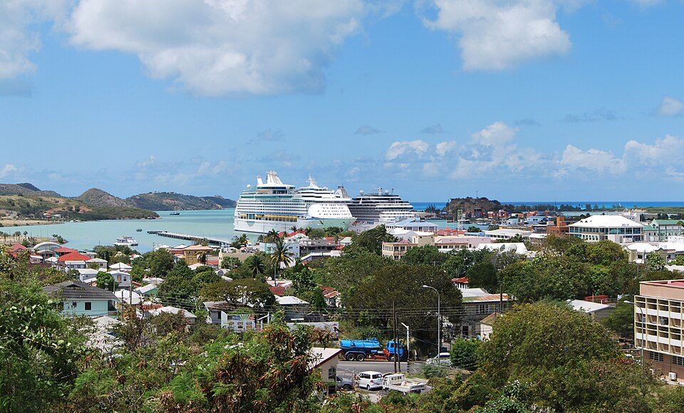
St. John’s, Antigua and Barbuda is a submarine cable landing point in Antigua and Barbuda (coordinates 17.0515°, -61.8579°). It serves 2 submarine cable systems, making it a multi-cable landing site in Antigua and Barbuda's international connectivity infrastructure.
St. John's is the largest city in Antigua and Barbuda. It is located in the western part of Antigua, surrounding St. John's Harbour. It is the main city of the Central Plain region. The city is Antigua and Barbuda's primate city, having a population of 22,219. St. John's also tends to dominate the parish of Saint John, which composes much of the city's metropolitan area. From its establishment after the French invasion in 1666, the city has rapidly grown, eventually replacing Falmouth as the island's dominant city. Wikipedia
Connected submarine cables
| Cable | RFS | Length | Owners |
|---|---|---|---|
| Antigua-St.Kitts | 1995 | 14 km | Liberty Networks |
| Eastern Caribbean Fiber System (ECFS) | 1995 | 1,730 km | AT&T, Claro Dominicana (Codetel), Guyana Telephone and Telegraph (GT&T), … |
Operators landing at St. John’s, Antigua and Barbuda
Cables landing at St. John’s, Antigua and Barbuda are operated by 6 distinct consortium partners and carriers, including AT&T, Claro Dominicana (Codetel), Guyana Telephone and Telegraph (GT&T), Liberty Networks, Orange, Verizon. Each cable is typically jointly owned by a consortium of tier-one carriers and hyperscale operators who share construction costs and capacity; the operator mix reflects both regional incumbents and global players with interest in the routes served by this landing point.
Connectivity profile
From St. John’s, Antigua and Barbuda, international traffic can reach 12 countries through 2 cable systems. Destinations include Anguilla, Barbados, Dominica, Grenada, Guadeloupe, Martinique, Saint Kitts and Nevis, Saint Lucia and 4 more.
Monitoring status
No monitoring incidents were recorded on cables serving St. John’s, Antigua and Barbuda in the past 90 days - all connected systems remained within normal latency thresholds. Our monitoring network continuously samples latency from external probes to targets reachable via these cables.
About the cables
- Antigua-St.Kitts (1995) - Antigua-St.Kitts is a point-to-point submarine cable linking Saint Kitts and Nevis and Antigua and Barbuda. Landing at Basseterre, St. John’s, it provides a direct fiber-optic path between the two countries, serving as both a primary data route and a redundancy option for neighboring cable systems. Read more →
- Eastern Caribbean Fiber System (ECFS) (1995) - Eastern Caribbean Fiber System (ECFS) is a regional submarine cable connecting 13 countries - Barbados, Saint Lucia, Trinidad and Tobago, Saint Kitts and Nevis, Saint Vincent and the Grenadines and others - with 13 landing points including Bridgetown, Barbados, Castries, Saint Lucia, Chaguaramas, Trinidad and Tobago, Frigate Bay, Saint Kitts and Nevis and others. Read more →
What next: St. John’s, Antigua and Barbuda in the global directory of cable landing points; see surrounding routes on the interactive submarine cable map or follow live network monitoring.
Other Landing Points in Antigua and Barbuda
Landing Point
- CountryAG Antigua and Barbuda
- Coordinates17.0515°N 61.8579°W
- Connected Cables2
See Real Cable Routes
View actual submarine cable routing from St. John’s, Antigua and Barbuda - with backbone nodes, distance calculations, and latency estimates
Open Calculator →